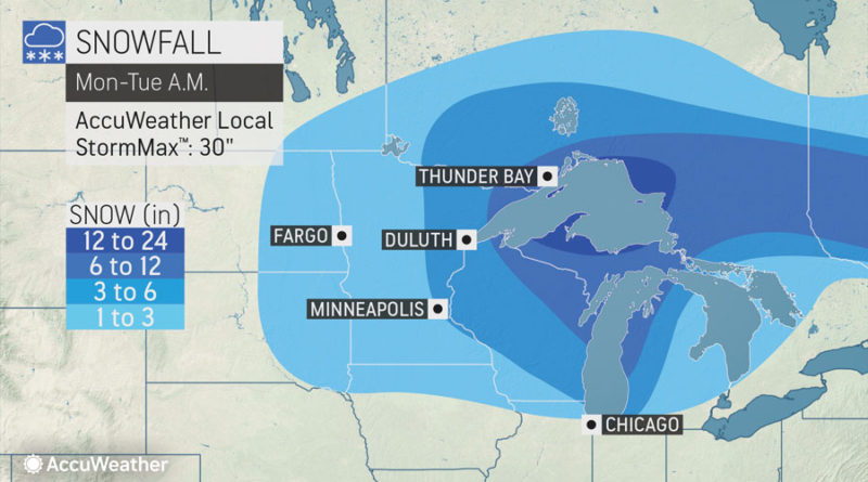
Snowstorm heading into Great Lakes area
By , AccuWeather meteorologist
The snowstorm that pummeled the northern Plains over the weekend may prove just as disruptive as it targets the Great Lakes with windswept snow early this week.
Snow will gradually wind down across the eastern Dakotas and western Minnesota into Monday night as the storm slowly pivots eastward. Gusty winds will continue to cause blowing and drifting problems in these areas even after the snow has ended.
As cold air wraps in behind the storm, places that had a seemingly springlike end to the weekend with rain and temperatures in the 50s and 60s F will turn wintry in a hurry.
“Following all rain so far with this storm, cities like Chicago and Detroit will have a wave of snow move through Monday night into Tuesday,” AccuWeather Meteorologist Courtney Travis said. A coating to an inch or two of snow can whiten both of these cities.
The timing of the snow can lead to dangerous conditions for people commuting on the morning of New Year’s Eve. In Detroit, it is possible that a heavier burst of snow, known as a snow squal moves in right around rush hour Tuesday morning.
“This snow squall, and others over the Lower Peninsula of Michigan as well as northern Ohio, northwestern Pennsylvania and western New York, have the potential to rapidly reduce the visibility and coat roads in a matter of seconds,” according to AccuWeather Senior Meteorologist Alex Sosnowski.
“As we have seen in recent weeks and prior years, snow squalls can be extremely dangerous for motorists traveling at high speed on the major highways,” Sosnowski added.
A widespread plowable snow is forecast after precipitation flips from rain to snow across Wisconsin and Michigan. By Tuesday morning, the northern tier portions of these states may be buried underneath a foot or more of fresh snowfall.


